Berkeley Hills resident Fan Chew loves walking in the hills, but she didn’t know much about the 126 pathways that traverse the steep slopes amid homes and streets.
That’s why she showed up Sunday morning on Grizzly Peak Boulevard with her husband and two kids in tow: to learn more about the Berkeley paths.
Specifically, Chew said, she wanted her family to get a sense of what it would be like to hit the paths if they needed to evacuate a wildland fire.
She was one of a few dozen people participating in “Escape from the Hills,” an evacuation education event of the Berkeley Path Wanderers Association to commemorate the 30th anniversary of the Oakland-Berkeley Hills Firestorm.
“I came so I could get familiarized with how to get away,” Chew said.
With the increase of destructive wildfires in the state, and the Berkeley Hills in the state’s highest fire-risk severity zone, Chew, like some others, is gathering all the facts to decide if she wants to stay in the area.
“The more we know how to be safe, that helps us maybe stay longer,” she said.
Volunteers from the nonprofit Path Wanderers led six path tours from the top of the hills to the flatlands to highlight their importance as an option for evacuation.
In a fire, streets might not be passable, with downed power lines or trees, and traffic jams. The paths are an option residents should know about, said Charlie Bowen, a long-time Path Wanderers volunteer.
“You can get down the hill without going on the streets,” she said. “There are quite a few choices of paths; try to be familiar with as many as you can.”
Berkeley’s network of pedestrian pathways was largely created by developers in the early 1900s to help residents of the hills reach streetcar and train lines. Owned now by Berkeley, the paths are largely maintained by the Path Wanderers, with help from the city.
Though October is prime fire season in the Bay area, Sunday morning was cool and overcast.
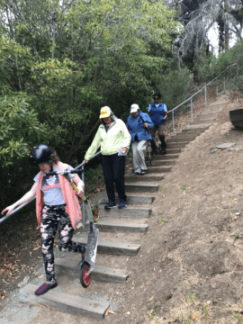
On one of the tour options, a group of about seven people descended from the top of the hills to the lowlands via the Anne Brower, Whitaker, Upper Covert, Lower Covert, Martinez and Redwood Terrace paths.
The paths were steep, and the pace was brisk. The walkers, all women except for a male radio reporter, donned hats, walking sticks and backpacks. They consulted maps Bowen had passed out.
My young daughter, who joined me as I reported this story, carried her scooter, using it when the paths intersected streets, to scoot across.
Genevieve Dreyfus, a hills resident, said she wants to know the most efficient ways out if “you have to drop your car and go fast.”
An important consideration for evacuating by foot is what you take with you, Bowen said. Carrying weight may slow the escape.
“Take the minimum,” she said. “It’s a tradeoff between how much potentially useful stuff you can put in your go-bag” she said, and the weight slowing you down.
A pre-packed “go bag” with emergency supplies is highly recommended by emergency planners for anyone living in a high-risk fire zone. Go bags should be kept in an easy-to-grab place, with one for each family member who’s able to carry it.
Among the chatter on the walk was discussion of what to do with pets if you’re evacuating via a path. One woman said she would bring her cat in a carrier.
Two of the tours ended at Live Oak Park. Some people got rides back up the hill; others trekked.
Chew said she’d like to learn even more about the paths, their histories and stories. She’s driven past so many without even knowing they were there, she said.
Sunday’s event was a helpful start, she said. “I’m learning: ‘What, there’s a path that goes here?” That’s the discovery I wanted.”
